This warm up will teach you how to tell the geologic past of an area using pictures. This will help you with Project Part B. Today, we'll look at NC's geologic past. For your project you'll chose an area on your invented supercontinent.
Illustrate the following statements with simple line diagrams:
1) The Carolinas were covered by ice.
2) The Carolinas rifted apart from Rodinia.
3) A chain of active volcanoes collided with the Carolinas making mountains.
4) South America and Africa hit the Carolinas causing huge mountains to form.
5) Over time, the mountains shrunk from weathering, erosion, and deposition.
Write and complete these sentences:
1) Rodinia was a _____________continent.
2) NC rifted apart from Rodinia at a ______________ plate boundary.
3) Mountains formed at ________________ plate boundaries.
4) The mountains HAVE or HAVE NOT (chose one) stayed the same height.
Happy Tuesday!
Ms. Nickel
Monday, January 28, 2013
It's a Date! Exploring Radioactive Dating
Today we will be exploring radioactive dating.
Radioactive dating is a type of absolute dating - it can help us figure out when a rock formed. It is especially useful in igneous rocks.
Rocks are made up of minerals which are made of elements. Some of these elements are radioactive. If an element is radioactive, it lets off radiation, which is a type of energy, as it decays/breaks down.
Please take the following notes (only the italics) in your science notebook:
A. Atomic structure of an element:
Elements are made up of three types of particles:
1. protons: these are found in the element's nucleus and have a positive (+) charge
2. neutrons: these are found in the element's nucleus and have no charge
3. electrons: these are found in the element's electron cloud and have a negative (-) charge

1) When you finish copying the notes, write your name and your partner's name on a sheet of notebook paper.
2) Ask me for a problem and work on it. Write the problem number and answer on your answer sheet.
3) When you finish, ask me to check your answer.
4) Get a new card.
5) At the end of the period, turn in your sheet. You do not need to do every problem. You do need to work efficiently for the entire period or you will lose points.
If you finish early, work on your project or Geologic Time Scale Walk questions.
Thanks!
Ms. Nickel
Radioactive dating is a type of absolute dating - it can help us figure out when a rock formed. It is especially useful in igneous rocks.
Rocks are made up of minerals which are made of elements. Some of these elements are radioactive. If an element is radioactive, it lets off radiation, which is a type of energy, as it decays/breaks down.
Please take the following notes (only the italics) in your science notebook:
Radioactive Dating
A. Atomic structure of an element:
Elements are made up of three types of particles:
1. protons: these are found in the element's nucleus and have a positive (+) charge
2. neutrons: these are found in the element's nucleus and have no charge
3. electrons: these are found in the element's electron cloud and have a negative (-) charge
B. Many elements have isotopes
1. Isotopes have the same number of protons, but a different number of neutrons
2. Sometimes even if an element is not radioactive, it's isotopes may be radioactive
3. Carbon (C) has a radioactive isotope, C-14, that decays to C-12 which is stable. Carbon is found
only in living or once living things
C. The nuclei of radioactive elements and isotopes decay...
1. ....to stable daughter products (Uranium (U) to lead (Pb))
2. ....at a defined rate called a half-life
a. half-life (t1/2): the amount of time it takes for half the nuclei of a radioactive sample to break
down/decay to a stable daughter product
b. t1/2 of Uranium-235: 703.8 million years (my)
c. t1/2 of Carbon-14: 5,730 years
1) When you finish copying the notes, write your name and your partner's name on a sheet of notebook paper.
2) Ask me for a problem and work on it. Write the problem number and answer on your answer sheet.
3) When you finish, ask me to check your answer.
4) Get a new card.
5) At the end of the period, turn in your sheet. You do not need to do every problem. You do need to work efficiently for the entire period or you will lose points.
If you finish early, work on your project or Geologic Time Scale Walk questions.
Thanks!
Ms. Nickel
Sunday, January 27, 2013
Geologic Time Scale Gallery Walk
Hey All-Star Scientists!
As and after we walk through the geologic time scale, use the post below to fill out your cards about the different time segments.
As you read the information below, answer these questions and take brief notes on your time scale cards.You may answer in illustrations, words, etc. You must be able to study from your cards, so plan accordingly. You will add to these during the time scale walk.
1) The atmosphere formed during the _____________. What created the atmosphere?
2) Track NC's geologic history on different cards.
3) Pangea formed during the ______________ period.
4) During which period was the last ice age?
During the Precambrian Era, the Earth and atmosphere form.

 Life is unicellular prokaryotes (one-celled organisms with no nucleus). Photosynthesis begins and this helps create the atmosphere.
Volcanic explosions of water and carbon dioxide help create the atmosphere and oceans. Banded iron formations appear because oxygen levels in the atmosphere and sea rise.

 Cambrian Era (540 mya to 490 mya)
Early life explodes. Life during the Cambrian Era included sponges, segmented worms, trilobites, and brachiopods.
The land that became North Carolina was near the equator. It was an island arc.
 Ordovician Period (490 mya to 443 mya)
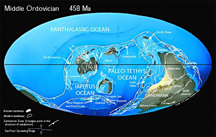 Early plants grew on Earth. There were trilobites, jawless fish, bivalve mollusks, nautiluses, and gastropods. Ice caps grew in what is now Northern Africa.
 Silurian Period (443 mya to 417 mya)
 Life during the Silurian included crinoids, trilobites, brachiopods, gastropods, coral reefs, fish with jaws, and nautiluses. Extensive erosion occurred.
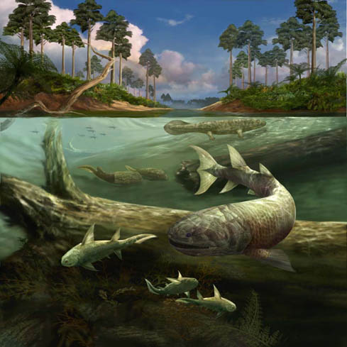 Devonian Period (417 mya to 354 mya)
 The Devonian was the age of fishes. Life includes ammonites, starfish, corals, crinoids, armored fish, sharks, early bony fish, and amphibians.
The Appalachians began to form.


Life includes snails, amphibians, sharks, and freshwater clams. Trilobite populations drastically decrease. Armored fish became extinct. There are tree ferns. The first plants with seeds appear.
Much of North America was underwater.
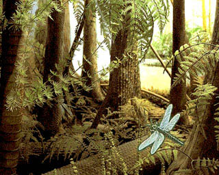
 Pennsylvanian Period (323 mya to 290 mya)
 Spiders, cockroaches, flying insects, early reptiles, and amphibians lived during the Permian. Cycads were one of the main plants.
Reptiles develop from amphibians.
There are huge swamps. These became today's coal deposits.

 Reptiles have moved onto land. Beetles, bugs, and ammonites are some of the main living organisms. Conifers (pine trees) grow on land.
At the end of the Permian Period there is a mass extinction and the fossil record changes dramatically.
Pangea forms and the Appalachians grow.

 Flying reptiles soar through the sky. Forests become more diverse, with cycads, yew trees, redwoods, conifers, and cypresses. There are dinosaurs!
The Rockies continue growing and North America separates from Africa.

 Dinosaurs dominate the animal kingdom. Flying reptiles still soar through the sky. Reptiles swim the seas. There are also amphibians, lizards, early crocodiles, and birds. Early mammals develop. Snakes and the first primates appear.
A mass extinction due to an asteroid impact at the end of the Cretaceous paves the way for mammals to take over the animal kingdom. Currently, geologists think the Gulf of Mexico is where the asteroid hit the Earth. There is a lot of evidence to support that location as the location of asteroid impact.
 Modern life becomes more and more diverse. Whales, dolphins, and manatees swim the seas. Amphibians, lizards, crocodiles, and snakes thrive. Early deer, antelope, and pronghorns roam the land. Cats, pigs, and weasels develop. The Tertiary Period ended with the beginning of the most recent ice age. Camels lived in South Carolina. Homonids develop.
 Earthquakes are common. Sea levels rise, the Appalachians uplift and erosion increases. There is a lot of volcanic activity in North America and Africa. The Grand Canyon forms.

 Giant ground sloths and beavers, mastodons, bison, saber-tooth cats, and mammoths thrive before the last ice age ended 10,000 years ago. Human beings evolve. Asian humans migrate and settle in the Americas. Extinction is common.
 After the end of the last ice age, large mammals died out and species of today became dominant.
Ice sheets form during the last ice age. After the end of the last ice age, beaches and barrier islands form in the southeast of the US.
 One method that scientists use to study the climate changes of the Quaternary Period is drilling and studying ice cores. In the world's polar regions, ice can be studied to learn about the climate as far back as 750,000 years ago. Every year, snowfall is compacted and becomes ice. Ice holds gases in it, specifically, CO2. Ice also contains...WATER. Water is made up of hydrogen and oxygen. There are different variations of hydrogen and oxygen (or any element) called isotopes. Scientists can look at the different ratios of isotopes of hydrogen and oxygen to figure out the temperatures during different parts of geologic past.
 From these ice cores, we can tell that the last continental glaciation (when continents were covered by glaciers) in North America was from 70,000 to 10,000 years ago. An interesting fact is that much of North Carolina and the Southern Appalachian mountain region was not covered in glaciers during that time period.
Task 3: Geologic Time Scale Walk
Task 4: Wrap-Up Questions (in your WU/ET notebook):
2) __________ cores can tell us about the climate of the past ____________ years.
3) WHAT DO YOU THINK QUESTION: The Southern Appalachian region was not covered by glaciers in the last ice age. How do you think this would impact life in the region?
Have fun exploring the past!
Ms. Nickel
As and after we walk through the geologic time scale, use the post below to fill out your cards about the different time segments.
Task 1: Time Scale Walk Prep
1) Look at your assigned card. As you read the information below, determine which time period your event or species is from.
2) Note this on your time scale card for that period along with one interesting fact.
3) During our Time Scale walk, you will present this to the class.
Task 2: Questions
1) The atmosphere formed during the _____________. What created the atmosphere?
2) Track NC's geologic history on different cards.
3) Pangea formed during the ______________ period.
4) During which period was the last ice age?
Precambrian Era (4500 mya to 540 mya)
During the Precambrian Era, the Earth and atmosphere form.
Life is unicellular prokaryotes (one-celled organisms with no nucleus). Photosynthesis begins and this helps create the atmosphere.Volcanic explosions of water and carbon dioxide help create the atmosphere and oceans. Banded iron formations appear because oxygen levels in the atmosphere and sea rise.
Cambrian Era (540 mya to 490 mya)Early life explodes. Life during the Cambrian Era included sponges, segmented worms, trilobites, and brachiopods.
The land that became North Carolina was near the equator. It was an island arc.
Ordovician Period (490 mya to 443 mya)Early plants grew on Earth. There were trilobites, jawless fish, bivalve mollusks, nautiluses, and gastropods. Ice caps grew in what is now Northern Africa.Silurian Period (443 mya to 417 mya)Life during the Silurian included crinoids, trilobites, brachiopods, gastropods, coral reefs, fish with jaws, and nautiluses. Extensive erosion occurred.Devonian Period (417 mya to 354 mya)The Devonian was the age of fishes. Life includes ammonites, starfish, corals, crinoids, armored fish, sharks, early bony fish, and amphibians.The Appalachians began to form.
Mississippian Period (354 mya to 323 mya)
Life includes snails, amphibians, sharks, and freshwater clams. Trilobite populations drastically decrease. Armored fish became extinct. There are tree ferns. The first plants with seeds appear.
Much of North America was underwater.
Pennsylvanian Period (323 mya to 290 mya)Reptiles develop from amphibians.
There are huge swamps. These became today's coal deposits.
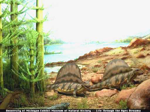
Permian Period (290 mya to 248 mya)
Reptiles have moved onto land. Beetles, bugs, and ammonites are some of the main living organisms. Conifers (pine trees) grow on land.At the end of the Permian Period there is a mass extinction and the fossil record changes dramatically.
Pangea forms and the Appalachians grow.
Triassic Period (248 mya to 206 mya)

Arthropods (early mites and beetles) and reptiles live on land. Therapsids, the first mammal-like reptiles, appear. Bony fish, turtles, other marine reptiles, and sea urchins live in the oceans. Early dinosaurs roam the seas and lands.
Pangea breaks apart. The Rockies and Sierra Nevadas form.
Jurassic Period (206 mya to 144 mya)
Flying reptiles soar through the sky. Forests become more diverse, with cycads, yew trees, redwoods, conifers, and cypresses. There are dinosaurs!The Rockies continue growing and North America separates from Africa.
Cretaceous Period (144 mya to 65 mya)
Dinosaurs dominate the animal kingdom. Flying reptiles still soar through the sky. Reptiles swim the seas. There are also amphibians, lizards, early crocodiles, and birds. Early mammals develop. Snakes and the first primates appear.A mass extinction due to an asteroid impact at the end of the Cretaceous paves the way for mammals to take over the animal kingdom. Currently, geologists think the Gulf of Mexico is where the asteroid hit the Earth. There is a lot of evidence to support that location as the location of asteroid impact.
Tertiary Period (65 mya to 2 mya)
 |
| Early homonids |
Modern life becomes more and more diverse. Whales, dolphins, and manatees swim the seas. Amphibians, lizards, crocodiles, and snakes thrive. Early deer, antelope, and pronghorns roam the land. Cats, pigs, and weasels develop. The Tertiary Period ended with the beginning of the most recent ice age. Camels lived in South Carolina. Homonids develop.
Quaternary Period (2 mya to today)
Giant ground sloths and beavers, mastodons, bison, saber-tooth cats, and mammoths thrive before the last ice age ended 10,000 years ago. Human beings evolve. Asian humans migrate and settle in the Americas. Extinction is common.Ice sheets form during the last ice age. After the end of the last ice age, beaches and barrier islands form in the southeast of the US.
One method that scientists use to study the climate changes of the Quaternary Period is drilling and studying ice cores. In the world's polar regions, ice can be studied to learn about the climate as far back as 750,000 years ago. Every year, snowfall is compacted and becomes ice. Ice holds gases in it, specifically, CO2. Ice also contains...WATER. Water is made up of hydrogen and oxygen. There are different variations of hydrogen and oxygen (or any element) called isotopes. Scientists can look at the different ratios of isotopes of hydrogen and oxygen to figure out the temperatures during different parts of geologic past.From these ice cores, we can tell that the last continental glaciation (when continents were covered by glaciers) in North America was from 70,000 to 10,000 years ago. An interesting fact is that much of North Carolina and the Southern Appalachian mountain region was not covered in glaciers during that time period.Task 3: Geologic Time Scale Walk
During the Geologic Time Scale Walk, present your information when we get to your time period/s. Take notes on what other people present.
1)) The period I would most want to visit is __________________ because _____________________.
3) WHAT DO YOU THINK QUESTION: The Southern Appalachian region was not covered by glaciers in the last ice age. How do you think this would impact life in the region?
Have fun exploring the past!
Ms. Nickel
Sources:
http://imnh.isu.edu/exhibits/online/geo_time/geo_time_periods.htm
http://www.bgs.ac.uk/climatethroughtime/
ftp://ftpdata.dnr.sc.gov/geology/Education/PDF/Geologic%20Time.pdf
http://dnr.wi.gov/org/caer/ce/eek/teacher/Climateguide/pdf/01-1823-icecores.pdf
http://dnr.wi.gov/org/caer/ce/eek/teacher/Climateguide/pdf/01-1823-icecores.pdf
Friday, January 25, 2013
Future of the Earth Project Part B: History of a Specific Place
Hey Hey Hey All-Stars!
For Part B of your project, which is due on Friday, February 1, you need to do the following:
1) Chose a specific place on your supercontinent. Label and name it on your map
2) Think about where your place was in 2013.
3) Draw a comic strip or flip book OR write a news story telling how your specific place formed.
Your final product should be neat, colorful, creative, free of grammatical errors, easy to follow, and scientifically accurate. Look at your project sheet and rubric for more information.
Here is a video showing how the Himalayas form. If you chose a mountain as your specific place and drew the images in this video showing how the mountains formed step-by-step you'd be on the right track!

Feel free to choose any other geologic formation for your specific place. Ask me if you are stuck! You can come in at lunch on Tuesday, Wednesday, or Friday!
I look forward to seeing your projects!
Ms. Nickel
For Part B of your project, which is due on Friday, February 1, you need to do the following:
1) Chose a specific place on your supercontinent. Label and name it on your map
2) Think about where your place was in 2013.
3) Draw a comic strip or flip book OR write a news story telling how your specific place formed.
Your final product should be neat, colorful, creative, free of grammatical errors, easy to follow, and scientifically accurate. Look at your project sheet and rubric for more information.
Here is a video showing how the Himalayas form. If you chose a mountain as your specific place and drew the images in this video showing how the mountains formed step-by-step you'd be on the right track!
Here is a diagram showing how rift valleys form on continents if your place is a rift valley:

This site explains how to write a news article if you chose that option.
This site has a Kim Possible-science-y comic that might spark some ideas. If you chose to make a flip book or comic, it should focus on the process of the geologic events. Extra credit may be awarded if I laugh when I read it :-).
I look forward to seeing your projects!
Ms. Nickel
Weekly Announcements Jan 28 - Feb 1
Hey All-Stars!
I hope you enjoy the wintery weekend! Travel safely if you are going anywhere!
Next week:
Monday: Geologic Time Scale Walk
Tuesday: How does radioactive dating work?
Wednesday: How do Mountains Shrink?
Thursday: How can we figure out relative age by looking at rock layers?
Friday: What do you remember from this unit so far?

Assignments due:
Monday: Future of the Earth Project Part A
Tuesday: Radioactivity Activity (in class)
Wednesday: Geologic Time Scale Walk Questions
Thursday:
Friday: Future of the Earth Project Part B
Monday, Feb 4: Lab Packet
IMPORTANT:
Please consider donating peanut butter, sunflower seed butter, cream cheese, jelly, whole wheat, or white bread for a lab that we'll be doing on Thursday.
Thanks! Have a lovely weekend!
Ms. Nickel
I hope you enjoy the wintery weekend! Travel safely if you are going anywhere!
Next week:
Monday: Geologic Time Scale Walk
Tuesday: How does radioactive dating work?
Wednesday: How do Mountains Shrink?
Thursday: How can we figure out relative age by looking at rock layers?
Friday: What do you remember from this unit so far?
Assignments due:
Monday: Future of the Earth Project Part A
Tuesday: Radioactivity Activity (in class)
Wednesday: Geologic Time Scale Walk Questions
Thursday:
Friday: Future of the Earth Project Part B
Monday, Feb 4: Lab Packet
IMPORTANT:
Please consider donating peanut butter, sunflower seed butter, cream cheese, jelly, whole wheat, or white bread for a lab that we'll be doing on Thursday.
Thanks! Have a lovely weekend!
Ms. Nickel
Thursday, January 24, 2013
Weather Alert!
Hey All-Stars!

Due to the weather we'll be having a short day tomorrow. Please bring your project materials to class as I think we'll have a project work day!
Ms. Nickel
Due to the weather we'll be having a short day tomorrow. Please bring your project materials to class as I think we'll have a project work day!
Ms. Nickel
Future of the Earth Project Part A: Create a Supercontinent, More resources
Hey All-Stars!
Here are some more resources for your supercontinent project!
The map of Davadinia would get a 14/20. It is colorful, but it is not neat. It is also not very scientifically based. It does have a good key, a compass, and the equator. There is no white space, and it is a supercontinent. Mountains are drawn at convergent boundaries. Mid-ocean ridges are drawn at divergent boundaries. The Antarctic Plate has moved above the other continents because it is currently located at the South Pole and is still moving south.
Note that I made up the shape of my continent, you can do this too!
You can also decide your continent has been flooded or frozen due to climate change. It's up to you!

The white map below is more scientifically based. This project would get a 16/20. It needs to be colored but it is very scientifically accurate. Many types of landforms are shown. The key is clear. The continents have continued moving in the current direction of plate motion, that is how North America and South America ended up on the other side of the Eurasian continent. Africa kind of disappeared though... So keep Africa in your map!
 GOOD LUCK! And remember you can work in class on this tomorrow!
Thanks for all your hard work!
Ms. Nickel
Here are some more resources for your supercontinent project!
The map of Davadinia would get a 14/20. It is colorful, but it is not neat. It is also not very scientifically based. It does have a good key, a compass, and the equator. There is no white space, and it is a supercontinent. Mountains are drawn at convergent boundaries. Mid-ocean ridges are drawn at divergent boundaries. The Antarctic Plate has moved above the other continents because it is currently located at the South Pole and is still moving south.
Note that I made up the shape of my continent, you can do this too!
You can also decide your continent has been flooded or frozen due to climate change. It's up to you!

The white map below is more scientifically based. This project would get a 16/20. It needs to be colored but it is very scientifically accurate. Many types of landforms are shown. The key is clear. The continents have continued moving in the current direction of plate motion, that is how North America and South America ended up on the other side of the Eurasian continent. Africa kind of disappeared though... So keep Africa in your map!

Thanks for all your hard work!
Ms. Nickel
Sunday, January 20, 2013
Future of the Earth Project Part A: Next Supercontinent
Hey All-Stars!
So, here are resources to use to create a map of your future supercontinent.
Remember that a supercontinent is when all continental crust is combined into one continent.
Here is a map of the plates in their current locations:

Here is a map showing how the plates are moving:

Remember that your supercontinent needs to be based on the current direction of plate motion. Show the plate boundaries and direction of motion on your map.
Here is one model that scientists have created predicting where the continents will end up:
NPR has some interesting resources too.
This site has information and videos about landforms at plate boundaries.
Here is a diagram showing landforms at plate boundaries:

Remember to label landforms on your map based on the direction of plate motion.
Here is a beautifully created handmade map. It's for a different project, but it has the same basic components your map needs to have:
1) A title with the name of your supercontinent
2) A compass
3) A key
4) Colorful map


So, here are resources to use to create a map of your future supercontinent.
Remember that a supercontinent is when all continental crust is combined into one continent.
Here is a map of the plates in their current locations:
Here is a map showing how the plates are moving:
Remember that your supercontinent needs to be based on the current direction of plate motion. Show the plate boundaries and direction of motion on your map.
Here is one model that scientists have created predicting where the continents will end up:
NPR has some interesting resources too.
This site has information and videos about landforms at plate boundaries.
Here is a diagram showing landforms at plate boundaries:
Remember to label landforms on your map based on the direction of plate motion.
Here is a beautifully created handmade map. It's for a different project, but it has the same basic components your map needs to have:
1) A title with the name of your supercontinent
2) A compass
3) A key
4) Colorful map
For extra credit you can create a 3-D map. Here is an example:
I'm excited to see your maps!!!
Ms. Nickel
Thursday, January 17, 2013
How old is the Earth???
Happy Friday All-Stars!
It's a long weekend! WOOT!

Today we will be playing a game of sorts to see how scientists tried to figure out the age of the Earth.
Create a sheet with the table below and the answers to the questions below.
Create a table with these three columns:
1) Points 2) Pts. Lost b/c 3) Pts. Earned b/c
record the points you get paraphrase why you paraphrase why you
as +x or -x lost points earned points
ex. -2 ex. 1) not scientific ex. 1) scientific method
+1 2) forgot about erosion
Play the game. When you finish the game, answer these questions under your table. You do not have to write the question. You do need to write the question number. You do need to WRITE IN COMPLETE SENTENCES!
1. The scientifically accepted age of the Earth is __________ billions of years old.
2. Briefly describe three ways people tried to find the age of the Earth. Explain why they were wrong.
3. Fill in the blanks: _____________ proposed uniformitarianism. Uniformitarianism proposes the __________________ is the key to the past.
4. Why was measuring sedimentation rates inaccurate?
5. Who discovered radioactivity? When?
6. How do scientists now figure out the ages of rocks?
7. What is the stable daughter product of uranium?
8. What is a likely explanation for why scientists have not found rocks on Earth that are as old as Earth is?
Make sure your name is on your paper. Turn your answer sheet in to the drawer for your period.
Happy long weekend!
Ms. Nickel
It's a long weekend! WOOT!
Today we will be playing a game of sorts to see how scientists tried to figure out the age of the Earth.
Create a sheet with the table below and the answers to the questions below.
Create a table with these three columns:
1) Points 2) Pts. Lost b/c 3) Pts. Earned b/c
record the points you get paraphrase why you paraphrase why you
as +x or -x lost points earned points
ex. -2 ex. 1) not scientific ex. 1) scientific method
+1 2) forgot about erosion
Play the game. When you finish the game, answer these questions under your table. You do not have to write the question. You do need to write the question number. You do need to WRITE IN COMPLETE SENTENCES!
1. The scientifically accepted age of the Earth is __________ billions of years old.
2. Briefly describe three ways people tried to find the age of the Earth. Explain why they were wrong.
3. Fill in the blanks: _____________ proposed uniformitarianism. Uniformitarianism proposes the __________________ is the key to the past.
4. Why was measuring sedimentation rates inaccurate?
5. Who discovered radioactivity? When?
6. How do scientists now figure out the ages of rocks?
7. What is the stable daughter product of uranium?
8. What is a likely explanation for why scientists have not found rocks on Earth that are as old as Earth is?
Make sure your name is on your paper. Turn your answer sheet in to the drawer for your period.
Happy long weekend!
Ms. Nickel
Wednesday, January 16, 2013
Shells on Mountains? What?
Carly Rae Jepsen just wrote a new song... ABOUT SHELLS ON MOUNTAINTOPS!
(That's kind of a lie. I rewrote the lyrics... And yes, they are silly)
I was hiking, found a shell,
Don't ask me, I'll never tell
I looked confused as it fell,
To a mountaintop, I'm on my way
I know for fossil shells you wish,
Look carefully or fossils you'll miss
I wasn't looking for this,
But fossils are in my way
North Face you were nearin',
Fallin' off of Everest you were fearin'
Cold night, wind was blowin'
Why's a fossil here, baby?
Hey, I just found it,
And this is crazy,
But here's my fossil,
So call me, maybe?
It's hard to look right,
At this fossil,
Because its so cold,
So call me, maybe?
Hey, I just found it,
And this is crazy,
But how'd it get here,
So call me, maybe?
And all the marine shells,
Are near beaches,
But here's a mountain,
So how'd it get here?
So, here's the deal, scientists have found shells on top of mountains. Would you expect to find them there?
I sure wouldn't! So we are going to figure out how they got there!
Step 1) Read your "Every Rock Sitting on the Ground" sheet. Answer the questions and turn it in.
Step 2) Draw shells on the four stickers you were given.
Step 3) Put the stickers in the middle of the aluminum foil.
Step 4) Play with the aluminum foil to get your shells to the top of a mountain.
Step 5) Unfold your mountain. Take of your stickers and put them somewhere NOT ON THE DESKS (ex. your face, your science notebook)
Step 6) Watch the powerpoint. List the three ways to form mountains in your notebook.
Happy Thursday!
Ms. Nickel
(That's kind of a lie. I rewrote the lyrics... And yes, they are silly)
I was hiking, found a shell,
Don't ask me, I'll never tell
I looked confused as it fell,
To a mountaintop, I'm on my way
I know for fossil shells you wish,
Look carefully or fossils you'll miss
I wasn't looking for this,
But fossils are in my way
North Face you were nearin',
Fallin' off of Everest you were fearin'
Cold night, wind was blowin'
Why's a fossil here, baby?
Hey, I just found it,
And this is crazy,
But here's my fossil,
So call me, maybe?
It's hard to look right,
At this fossil,
Because its so cold,
So call me, maybe?
Hey, I just found it,
And this is crazy,
But how'd it get here,
So call me, maybe?
And all the marine shells,
Are near beaches,
But here's a mountain,
So how'd it get here?
So, here's the deal, scientists have found shells on top of mountains. Would you expect to find them there?
 |
| Shells in limestone in the Grand Canyon, elev. approx. 7000 ft. |
Step 1) Read your "Every Rock Sitting on the Ground" sheet. Answer the questions and turn it in.
Step 2) Draw shells on the four stickers you were given.
Step 3) Put the stickers in the middle of the aluminum foil.
Step 4) Play with the aluminum foil to get your shells to the top of a mountain.
Step 5) Unfold your mountain. Take of your stickers and put them somewhere NOT ON THE DESKS (ex. your face, your science notebook)
Step 6) Watch the powerpoint. List the three ways to form mountains in your notebook.
Happy Thursday!
Ms. Nickel
Monday, January 14, 2013
Continental Drift and Plate Tectonics Wrap Up
Hi there All-Stars!
To wrap up our discussion of the Hypothesis of Continental Drift and Theory of Plate Tectonics, we'll watch these video clips.
To wrap up our discussion of the Hypothesis of Continental Drift and Theory of Plate Tectonics, we'll watch these video clips.
Thanks for the cool video!
Convecting noodles :-)
Convection model
Convection in the Earth
We'll now finish your blue note sheet and lab packet.
Ms. Nickel
Tectonic Snacks Lab Resource
Hey All-Stars!
Here is the resource to go with the lab. This will help you fill in your lab packet and it will be great for when you study for your test!
Divergent plate boundary: Where two plates pull apart, crust is created here
Transform plate boundary: Where two plates slide against each other, crust is not created or destroyed here

Metamorphic rocks: A type of rock that forms when rock undergoes heat and pressure so the rock is not melted completely but it is changed
Sedimentary rocks: A type of rock that forms when pieces of other rocks break and are compacted to form rocks

Make sure you save your lab after I return it to you!
Have fun!
Ms. Nickel
Here is the resource to go with the lab. This will help you fill in your lab packet and it will be great for when you study for your test!
Types of Plate Boundaries:
Convergent plate boundary: Where two plates come together, crust is destroyed hereDivergent plate boundary: Where two plates pull apart, crust is created here
Transform plate boundary: Where two plates slide against each other, crust is not created or destroyed here
Types of Rocks:
Igneous rocks: A type of rock that forms when molten material hardensMetamorphic rocks: A type of rock that forms when rock undergoes heat and pressure so the rock is not melted completely but it is changed
Sedimentary rocks: A type of rock that forms when pieces of other rocks break and are compacted to form rocks
Make sure you save your lab after I return it to you!
Have fun!
Ms. Nickel
Sunday, January 13, 2013
Weekly Announcements: Week of Jan 14-18
HAPPY MONDAY ALL-STARS!
It's almost the end of the semester! Wooowhooooo :-).
Here's what we'll be exploring this week:
Monday: Wrapping up evidence for the Theory of Plate Tectonics
Tuesday: Tectonic Snacks Lab
Wednesday: Tectonic Snacks Lab work day
Thursday: Explore how shells get on top of mountains...WHAT?
Friday: Try to figure out the age of the Earth the way scientists did lots of years ago
Assignments due:
1) Wednesday: Turn in blue note sheet on continental drift and plate tectonics (done in class!)
2) Thursday: Turn in Tectonic Snacks Lab packet (should be finished in class!)
3) Thursday: Turn in Every Rock Sitting on the Ground reading (done in class!)
Last grades of the semester! YOU CAN DO IT!!!
Remember, if you'd like to earn Starbucks, consider donating lab materials!
Thanks a bunch for your consistent awesomeness!
Ms. Nickel
It's almost the end of the semester! Wooowhooooo :-).
Here's what we'll be exploring this week:
Monday: Wrapping up evidence for the Theory of Plate Tectonics
Tuesday: Tectonic Snacks Lab
Wednesday: Tectonic Snacks Lab work day
Thursday: Explore how shells get on top of mountains...WHAT?
Friday: Try to figure out the age of the Earth the way scientists did lots of years ago
 |
| This is not what tectonic plates look like... :-) |
Assignments due:
1) Wednesday: Turn in blue note sheet on continental drift and plate tectonics (done in class!)
2) Thursday: Turn in Tectonic Snacks Lab packet (should be finished in class!)
3) Thursday: Turn in Every Rock Sitting on the Ground reading (done in class!)
Last grades of the semester! YOU CAN DO IT!!!
Remember, if you'd like to earn Starbucks, consider donating lab materials!
Thanks a bunch for your consistent awesomeness!
Ms. Nickel
Sunday, January 6, 2013
Weekly Announcements Jan 7-11
Helloooo All-Stars!
Happy FIRST FULL WEEK OF 2013!
Here's what we'll be up to this week:
Monday: Working on Crash Course to the Center of the Earth Mini-Project
Tuesday: Presenting Crash Course to the Center of the Earth Mini-Project
Wednesday: Mini-quiz (don't freak out, it's simple), start Tectonic Plates Puzzler
Thursday and Friday: Tectonic Plates Puzzler (building evidence for the Theory of Plate Tectonics)
Assignments for the week:
Monday: In-class notebook check (not for a grade)
Tuesday: Turn in rubric for Crash Course to the Center of the Earth Mini-Project
Wednesday: Mini-quiz (Once I return it, save it to build a study guide!)
Friday: Turn in Tectonic Plates Puzzler for a note check

If you would like to earn Starbucks:
Bring in ONE of the following: a box of tissues, a container of frosting, fruit roll ups (the square type), graham crackers, sandwich bread, cream cheese, peanut butter, jelly
These are for future labs that we will be doing. I'd really appreciate donations, hence the incentive :-).
And of course, you can also earn Starbucks for excellent positive behavior in the classroom!!
Happy Monday! I'm looking forward to a wonderful week!
Ms. Nickel
Happy FIRST FULL WEEK OF 2013!
Here's what we'll be up to this week:
Monday: Working on Crash Course to the Center of the Earth Mini-Project
Tuesday: Presenting Crash Course to the Center of the Earth Mini-Project
Wednesday: Mini-quiz (don't freak out, it's simple), start Tectonic Plates Puzzler
Thursday and Friday: Tectonic Plates Puzzler (building evidence for the Theory of Plate Tectonics)
Assignments for the week:
Monday: In-class notebook check (not for a grade)
Tuesday: Turn in rubric for Crash Course to the Center of the Earth Mini-Project
Wednesday: Mini-quiz (Once I return it, save it to build a study guide!)
Friday: Turn in Tectonic Plates Puzzler for a note check
If you would like to earn Starbucks:
Bring in ONE of the following: a box of tissues, a container of frosting, fruit roll ups (the square type), graham crackers, sandwich bread, cream cheese, peanut butter, jelly
These are for future labs that we will be doing. I'd really appreciate donations, hence the incentive :-).
And of course, you can also earn Starbucks for excellent positive behavior in the classroom!!
Happy Monday! I'm looking forward to a wonderful week!
Ms. Nickel
Tuesday, January 1, 2013
Welcome Back! Weekly Plan for Jan 2-4
Welcome back All-Stars!
I hope you all had a wonderful holiday break!
This week we will be starting our Geology and Evolutionary Biology unit! I'm very excited!
Here's a timeline for the week:
Wednesday: Introduction to NC geology and biology
Thursday: Wrap up intro and begin a crash course journey to the center of the Earth
Friday: Crash course journey to the center of the Earth
Assignments due:
-Note sheet that we'll work on tomorrow in class
-Jigsaw activity on layers of the Earth (Due Tuesday Jan 8th)
*ALL Fracking Debate Project packets should be turned in! They are late if I did not receive them before break.
Happy 2013!
Ms. Nickel
I hope you all had a wonderful holiday break!
 |
| My sister's dog, Moose, shredding his Christmas present after having it for 1 minute. |
 |
| My mom's dog, Ralph, falling asleep... |
Here's a timeline for the week:
Wednesday: Introduction to NC geology and biology
Thursday: Wrap up intro and begin a crash course journey to the center of the Earth
Friday: Crash course journey to the center of the Earth
Assignments due:
-Note sheet that we'll work on tomorrow in class
-Jigsaw activity on layers of the Earth (Due Tuesday Jan 8th)
*ALL Fracking Debate Project packets should be turned in! They are late if I did not receive them before break.
Happy 2013!
Ms. Nickel
Subscribe to:
Posts (Atom)